

Reference Material
THE ORIGINS OF SOME OF OUR DALGETY STREET NAMES
Contributor: Jonathan Ellington
The background to some of our street names are obvious, eg, they have been drawn from well-known geographical features or terms relating to the airfield and the types of planes that used it. What we are doing today is investigating seven terms and names with interesting heritage backgrounds that are used in our street names and might not be known to all. We may possibly revisit this subject in later weeks with further examples.
STEEPLE CRESCENT
Over two years ago we posted about the Steeple Clump AAA Battery. This was a heavy anti-aircraft battery and was manned in 1940 by the 71st (Forth) Heavy Anti-Aircraft Regiment, Royal Artillery. It consisted of four gun-emplacements with sunken magazines between each of them. The station had a command position, an accommodation block and to the immediate SW an accommodation camp.
On the thread, a number of us were intrigued as to the naming of the clump, why Steeple? On the map, Pic 1, positioned at ‘3 o’clock’ from the stump, there is a reference to a ‘steeple’ and the Heritage Trail were minded finding out why.
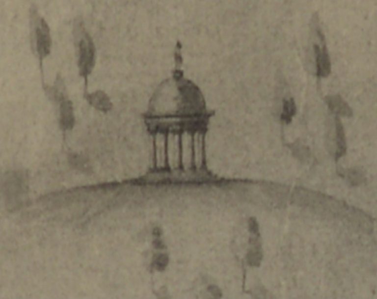
“The Steeple” was situated east of what is now Steeple Clump. Its W3W location was “online.rotation.built”. (Note: now private land). Steeple Crescent is thus a little north of the site. An 18thc plan for a developed Donibristle estate, shows, at Pic 2, an artist’s impression of The Steeple as being similar to a pavilion or covered seating area sparsely surrounded by trees. It was thus likely to have been part folly and part complementary to the various Summer Houses on the estate.

Pic 1
Pic 2
COUSTON DRIVE/ROAD/PLACE
Couston is the area roughly running from just south of Loch Otterston to the fields just north of Moss Plantation. The area was first mentioned as long ago as the end of the 12th C, when “Colestun”, which was owned by Robert of London, an illegitimate, though acknowledged and apparently favoured, son of William, King of Scots, was granted along with two other tranches of land in Aberdour, to Roger Frebern, in exchange for the military service of “one sergeant with horse and hauberk”, a hauberk being a chain mail shirt. This deal was obviously acceptable to both parties, though possibly less so to the unfortunate tenant of Frebern who was obliged to undertake the military duties!
Couston Castle, on the banks of Loch Otterston, was a 17th c “L shaped” tower house”, owned firstly by the Logan family, then by the Earls of Moray. In the 1980’s, the ruins of the castle were purchased by the Dunfermline businessman Alastair Harper, who had it rebuilt to great acclaim for its attention to period detail and quality of workmanship.
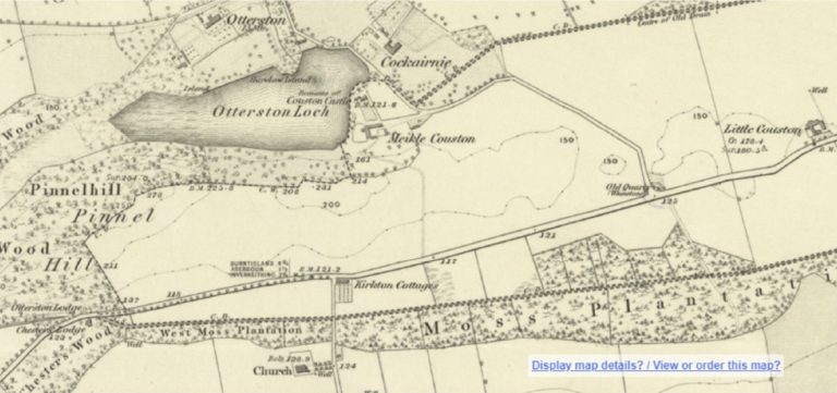
The Couston farmstead, otherwise known as Meikle Couston is a, still standing, group of 19th c buildings. An earlier site of the Meikle Couston farm buildings was just north of the present site – see Pic 3. Brian has previously covered the history of the farm on this page at:
We also discussed the unfortunate fate of John Brown, a blacksmith from Couston at:
There has been, since at least 1775 per the Ainslie map of Fife, a farmstead at Little Couston, nearer to Aberdour on what is now the A921. The current farm appears to be much more substantial than it was in previous years.
Pic 3
CRAIGDIMAS GROVE
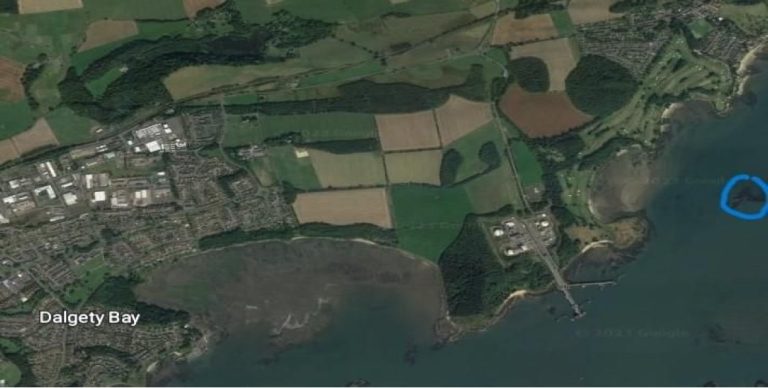
Craigdimas (Pic 4) is a small island or skerry, that is situated just off Barnhill Bay, by Aberdour Golf Club. Craig is believed to be derived from the Gaelic “Creag”, meaning rock, but the meaning of “Dimas” is unknown. At high tide, very little of the skerry is above water. The W3W reference for the island is “walked.mocked.mulls”.
Pic 4
MARKFIELD ROAD
Markfield Tower will be remembered by early residents of the Bay as being a tower that stood on the hill ridge at Otterston just to the North West of the Eastern Access Road, from where it could be seen clearly on leaving the Bay. It has now been demolished, presumably for safety reasons, but it was described in www.britishlistedbuildings.co.uk as a:” Square 19th cent. look-out tower built of rubble. Corbelled parapet. Buttressed angles. Door-lintel inscribed ‘Markfield’. Gutted.”
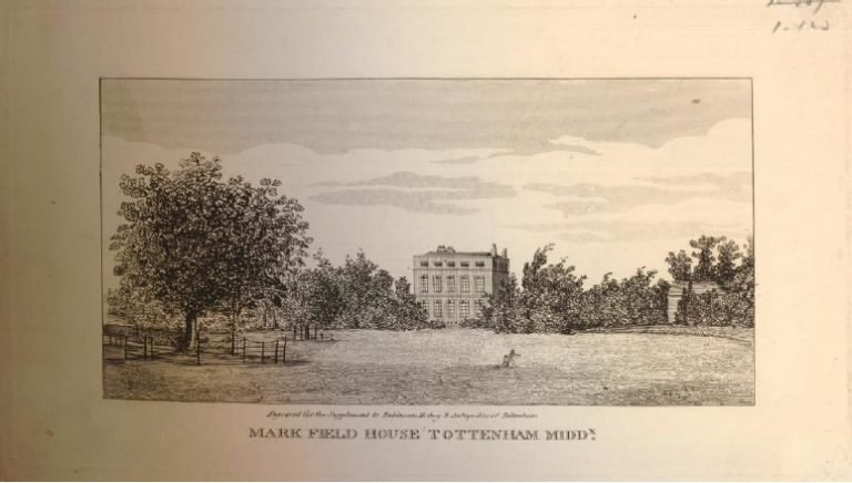
Markfield house – see Pic 5, built in 1798, was a mansion in Tottenham (then a mere village) owned by William Hobson, who was a successful and well-known builder. He was involved in the rebuilding of St. Luke’s Hospital, the construction of London Docklands and Newgate Gaol. He was most renowned, however, for the building of many “Martello Towers” on the English South and East coasts to protect against a possible French invasion. Many of these squat, round defensive structures still survive to this day.
Hobson’s wife, Ann Rickman, bore him sixteen children. The seventh born, Laura (b 1788), married Robert Moubray of Cockairnie and Otterston, Deputy Lieutenant of Fifeshire and the tower (and Laura’s Mount, a little further north) was clearly a tribute to her and her family, possibly with a nod to Hobson’s Martello Towers. We have also previously mentioned Laura’s portrait by Constable, a family friend of the Hobsons at:
Pic 6 shows Cockairnie house at Loch Otterston, the family home of the Moubrays
Pic 5

Pic 6
LT SALES AVENUE
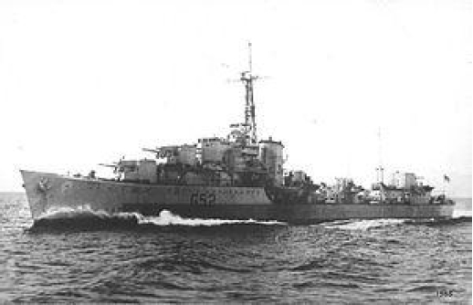
Brian Denyer Sales b 1924, Erpingham, Norfolk. d 1989 Stoke-on-Trent was a naval officer who had served on the destroyer HMS Matchless in 1943 – see Pic 7, the ship being involved in Arctic convoys and the sinking of the renowned German battleship Scharnhorst in the Battle of the North Cape. He was posted to HMS Merlin, Donibristle, for a brief period late in 1946.
His name is commemorated for the poignant poem etched by him on a window of the sick bay in the barrack huts at Donibristle . This building still exists as the home of Westgarth Auto Services. The actual pane was removed and framed and is now to be seen on the west end wall of Dalgety Bay Library. I tried to take photos of it for this piece but, unfortunately, it is not in non-reflecting glass, and I could not get a decent
photo under the artificial light.
Words:
Brian D Sales – Lieutenant, Royal Naval Volunteer Reserve
HMS Merlin March – December 1946
Dear Friend
Pause in thy labours for a while,
And offer up a silent prayer,
That they who toiled here once, but are now gone,
May triumph in the great grim fight,
For life and liberty in the world outside
Pic 7
FRANKFIELD PLACE, CRESCENT AND ROAD
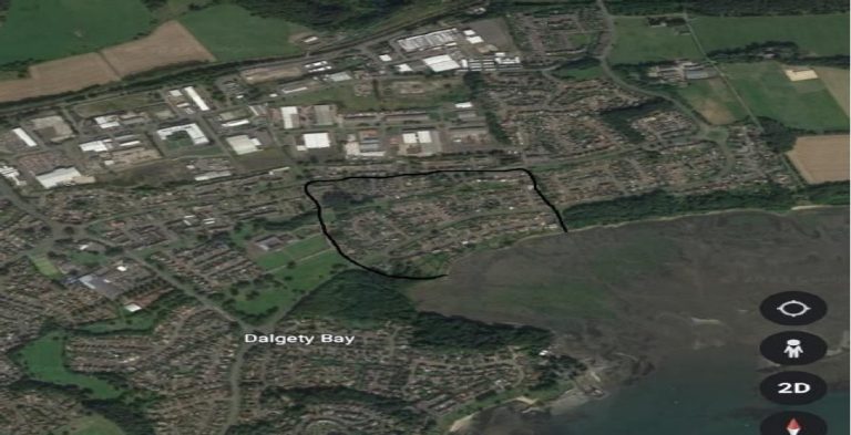
Frank Field was a large field or enclosure in the Donibristle Estate. The modern Frankfield area is just outside, to the east, of the perimeter of the Frank Field, whose boundaries are the deep ditch at College Bridge to the East, roughly the line of St Bridget’s Brae to the west and the cart track that approximately ran where Moray Way North runs today. These boundaries are shown in the Donibristle estate plan of 1811; however, a single death was recorded in the area in 1724, indicating that the area name was such for much a longer period. There is no evidence for the enclosure having any settlements in it, though the first manse, built in 1646 was, of course, at the east end of Sealstrand. It is conceivable that the western boundary was also a boundary between the Dalgety and Leuchat estates, though this is only being proposed based on plausibility, with no firm evidence available. Pic 8 shows the imprint of the old Frank Field on modern Dalgety Bay.
Pic 8
DALGETY HOUSE VIEW AND DALGETY GARDENS
The original Dalgety House, seat of the Dalgety Estate, was probably built in the 16th C for the Abernethy family, and is shown in early, though rather unreliable, maps as being roughly in the modern Dalgety Gardens area, references being made from its time of ownership by the Setons, Earls of Dunfermline as having high quality gardens in the vicinity. We shall return in another week to look at Dalgety House in more detail.
Whilst many know of the earlier Dalgety House, far fewer are aware that there was a later, Victorian, Dalgety House, which was situated at the east end of today’s Dalgety House View (see Pic 9, a spyglass view of the 2nd edition 25in OS map on today’s background – now private property). This house is not discussed in historical articles, possibly because it was built soon after the OS Name books of 1853-55 so was not mentioned in them. The house survived until the first phase of housebuilding infrastructure was commenced in the early to mid-1960s. It is quite possible then, that Dalgety House View was named after the later Dalgety House not the original. The location of the house puts it close to the Doocot and entrance archway to Dalgety Gardens, which were both located on the site now occupied by the roundabout off the
eastern access road.
As we can see from Pic 9, it was quite a substantial house. Victorian newspaper reports prove that it was the tied house of the Head Forester for the Donibristle estate and Church fetes were held in its garden. The new Dalgety House was thus probably the third most important home on the estate, after Donibristle House and St Colm House, which was the home of the Earl’s Commissionaire for all of his estates. More junior
foresters were known to stay at Chester’s.
The walls seen isolating the modern Dalgety Gardens, and part of Dalgety House View, were part of the Victorian gardens, which stretched down into modern Barnhill Road. These walls are rubble built but clearly reuse old building stone – some of it of a very high, ashlar quality. It is a tantalising thought as to what buildings originally used these stones, and where they were. The gardens themselves were formal and decorative, with walks and specimen trees. The original gardens created by the first Earl of Dunfermline are reported to have been beautified “down to the sea”, so they may have been even larger.

Pic 9
Acknowledgements and thanks:
Staff of Dalgety Bay Library and Westgarth Auto Services for Lt Sales Ave. information
The Place Names of Fife – Taylor & Markus
Wikipedia
www.tottenham-summerhillroad.com (Alan Swain)
www.unithistories.com/officers/RNVR_officersS.html
British Newspaper Archive (Various)
Andy Sweet of www.stravaiging.com
https://britishlistedbuildings.co.uk
National Library of Scotland – various maps
www.poms.ac.uk/record/source/890/
Dalgety Bay – Heritage and Hidden History, by Eric Simpson
Colin Johnston
Fife Death Index 1549-1877. Fife Family History Society / FindMyPast.co.uk
Photos and Picture acknowledgements:
Pic 1 NLS OS 6 in 1896 Edition on a Google background map
Pic 2 National Records of Scotland RHP14331, Copyright of, and with thanks to, the Earl of Moray for
permission to use.
Pic 3 NLS OS six in. 1st Edition
Pics 4 and 8 Google Earth
Pic 5 The British Museum
Pic 6 MJ Richardson www.geograph.org.uk (Attribution-ShareAlike 2.0 Generic (CC BY-SA 2.0)
Pic 7 Wikipedia
Pic 9 NLS OS 25 in 2nd Edition on a Google background map
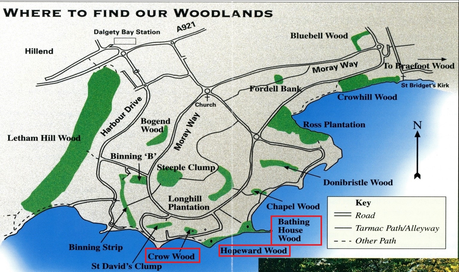
Where to Find Our Woodlands
DALGETY HERITAGE WALKS - #1 BEECH AVENUE
One of the purposes of building up our What Three Words Database of Dalgety Heritage sites has been to enable the preparation of a series of walks around the old parish which will each be highlighted with heritage sites on their routes, with access to information pertaining to these sites.

Picture 1: BEECH AVENUE WALK
In this, the first such Heritage walk, we are taking a trek along Beech Avenue from Dalgety to Aberdour, an everpopular route – see PIC 1. Beech Avenue was so called because it was lined with majestic Beech trees during its’ time as part of the Donibristle estate. Beech trees are relatively short lived for such a large tree, with poor roots for their massive size. They do not bear up well in sodden, windy Scotish climes so there are few originals left, though there are still some substantial specimens near St. Colme House with smaller, more recent plantings along the walk.
We start our walk at the gate just to the east of St Colme Drive. Access here can be either via the “Path of Gavin” on St Colme Drive or from the North or South of the, also historic, road that runs from the Cornerstone Full Gospel Church down to St Bridget’s kirk via Barns farm.

HERITAGE SITES ALONG THE ROUTE
SITES 1) to 8) ARE PER PIC 2:
1) A metal detectorist found a LATE BRONZE AGE GOUGE of Copper alloy in the field immediately to your right on entering the Beech Avenue.
Approximate W3W site: ///bucks.shampoo.tangent
Info: https://canmore.org.uk/site/369745/dalgety
2) The longstanding tiny settlement of MUIRTON (or Moortown) was situated on the northern side of the little farm crossroads at the end of the early straight portion of the Avenue. This long, straight stretch of the route was at least partially in existence by, at the latest, 1755, as it features in the Roy Military map of that year, connecting Dalgety House to Muirton, which was probably its’ “Home Farm”. Some early, though unreliable, maps show most, or all buildings in the near corner of the north western field next to the farm track running up the hill.
Site: ///corrode.decisions.valuables
3) At the top of this hill, via the farm track northwards, where there is now a Barns Farm working area, was the early prototype FARM BUILDING that superseded the settlement of Muirton, probably in the early 1800’s.
Site: ///deployed.robots.brimmed
4) Between these two, to the west of the farm track, and half way up the hill, was a WELL.
Site: ///relocated.frock.garages
We have written about the history of Muirton at:
MURDEROUS MUIRTON………. Heritage… – Dalgety Heritage Trail | Facebook
5) Further on, at Temple Plantation, near the front of the trees, can be seen a drystone revetment that is the only remains of a VICTORIAN SUMMERHOUSE used by the Earl of Moray’s Commissionaire, who resided at St Colme House.
Site: ///additives.extremely.subbed
6) There are also two small old QUARRIES in the plantation,
Sites: ///flask.untrained.melon and ///conned.bulletins.minder
7) Just after passing Temple Plantation, on the same, northern side, is a small hill in the same the field as the large radio mast that was originally built for the newly opened Radio Forth station in 1975 and is now (I believe) used by Shell/Exxon. This broad area was the site of a notable BRONGE AGE CEMETERY find in 1973.
Site: ///valuables.saving.player
Heritage Trail Post by Robin Arnott: (1) Dalgety and the Bronze Age. Contributed… – Dalgety Heritage Trail | Facebook
A detailed scientific paper (PDF) is available at: The excavation of an Early Bronze Age cemetery at Barns Farm, Dalgety, Fife | Proceedings of the Society of Antiquaries of Scotland (socantscot.org)
8) In the field opposite the burial site, during WWII, there was a DECOY ANTI-AIRCRAFT BATTERY site.
Site: ///conspired/access/enrolling
Info: Dalgety Bay, Temple Plantation, Decoy Anti-aircraft Battery | Canmore
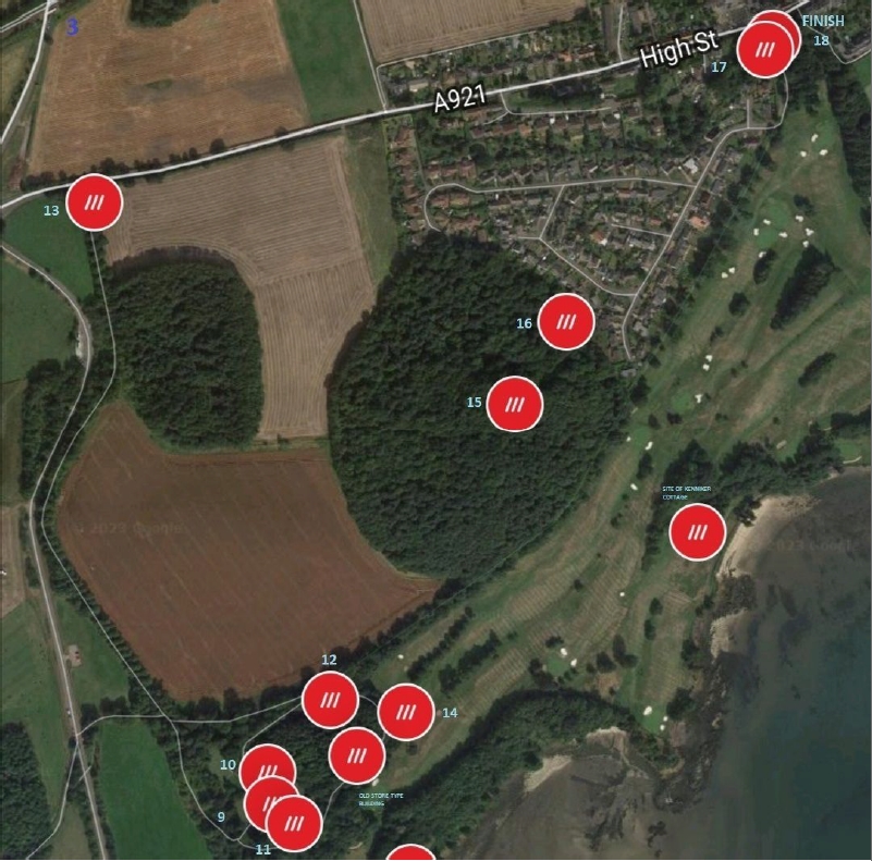
SITES 9) to 18) ARE PER PIC 3:
9) Further again, not far after the modern subway under the road to the Braefoot complex, ST COLME HOUSE is situated, to the South of the Avenue, but it is not immediately visible. It is private property but can be seen from a path that passes southward from Beech Avenue into a small, wooded area.
Other associated sites of historical interest, though again, unfortunately in the private grounds, are the COACH HOUSE and GARDENS, 10) including GATES and a SUNDIAL, 11). The remains of an ICEHOUSE 12), can be seen on the north facing slope of the wooded hill a little further along the Avenue past St Colme House.
Sites:
St Colme House: ///sharpness.thumbnail.tunes
Coachhouse etc ///media.instilled.relay
Sundial ///homing.unpacked,newest
Icehouse ///scrolled.stacks.shapeless
13) A short detour Northward at St Colme House, up the St Colme Avenue, will take you to the ST. COLME LODGE HOUSE, which was used to control access to St Colme House. Note that this is a private property and is effectively on a cul-de sac now. You will have to turn back along the same route to reach the Avenue again.
Site: ///widest.corrupted.unheated
Info for 9) to 13): St Colme House, Inverkeithing and Dalgety Bay, Fife (britishlistedbuildings.co.uk)
and: http://portal.historicenvironment.scot/designation/LB6633
St Colme House was built on the site of the earlier Barnhill Fermtoun, also known in earlier days as the Grange of Barnhill, an old map features the settlement, marked “2” at:
https://bit.ly/3saDWtg
14) The fairways at the west end of Aberdour Golf Course are probably the best parts of the course to see shadows of ancient runrig or ridge and furrow farm workings, more easily viewed with low lying winter sun.
Site: ///fatigued.siesta.dramatic
Photo: https://bit.ly/448oc7p
15) The large Downans Plantation, just before the Dovecot Estate in Aberdour, features what may be an old HILLTOP ENCLOSURE OR FOLLY at the top of the very steep hill. At the foot of the hill on the eastward side, just where it meets the new estate is where the tiny SETTLEMENT OF DOWNANS was situated, 16).
Possible Hilltop Enclosure or Folly approximate Site: ///giraffes.tasks.classed
Approximate site of Toft settlement: ///sample.mailers.apartment
Information regarding Downans can be found at:
https://bit.ly/44gRAZq
17) At the end of the Dovecot estate, and at the termination of this walk as we enter Aberdour, we meet the DONIBRISTLE EAST LODGE, built in 1870, (private property) and, just after that, 18), the WROUGHT IRON EAST LODGE GATES were situated, though only the gateway now remains.
Lodge Site:///unwound.streak.jets
Gates site: ///comfort.replying.rummage
Anyone who wishes to have access to our full “What Three Words” project, or who does already have such access, but not to a recent version of our database, should send us a Direct Message to confirm interest and we will guide you through the simple steps required.
Picture credits:
Pic 1 – Google Maps
Pic 2 and Pic 3 – What Three Words (Sample from Dalgety Heritage Trail Sites Database) & Google Maps